Links to other sites

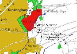
Extract: Sandringham. Enlarge »
- The Norfolk Record Office has an original of the map as does the Norfolk Heritage Centre at the Norfolk and Norwich Millennium Library at the Forum.
- Consult The Norfolk E-map scheme for historic maps of the county.
- The Norfolk Record Society brought out a facsimile of the map in its 1975 Volume XLII.
- The Larks Press produces Faden's map in 36 sheets (A4 size) at £6.95. The introduction to the map by J C Barringer is very informative.
- Old Hampshire Mapped from the Geography Department, Portsmouth University provided the inspiration for creating our map explorer
- In 2009 Andrew completed the digital redrawing of Faden’s ‘The Country Twenty Five miles round London planned from a scale of one mile to an inch’, first published in 1788. Visit the dedicated web site for the London map here.
- 2010 saw the publication of Andrew’s digital redrawing of Hodskinson’s Map of Suffolk (first published in 1783). Visit the Suffolk map web site here.
- In 2012 the Dury & Andrews 1766 Map of Hertfordshire was published.
- In 2015 Chapman André’s 1777 Map of Essex was completed.
- Most recently, in 2020 Richard Horwood’s 1799 Map of London was completed.
A similar map for Cambridgeshire will be published in the near future.